Land surveys are an important tool for defining property boundaries and the location of a property’s attributes. It would be impossible to determine where one piece of land ends and another begins without land surveys. Property issues may not lead to as much turmoil as they did centuries ago, but it’s still critical for everyone to understand who owns what.
What is a Land Survey?
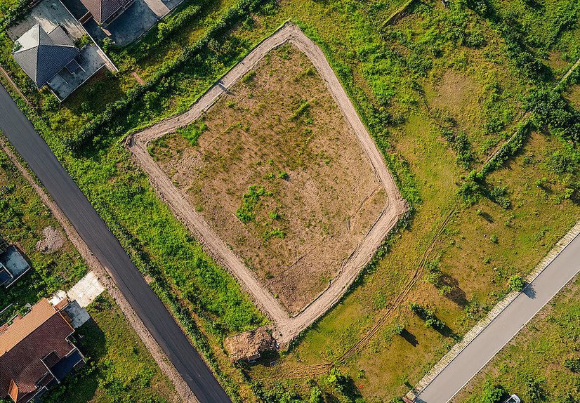
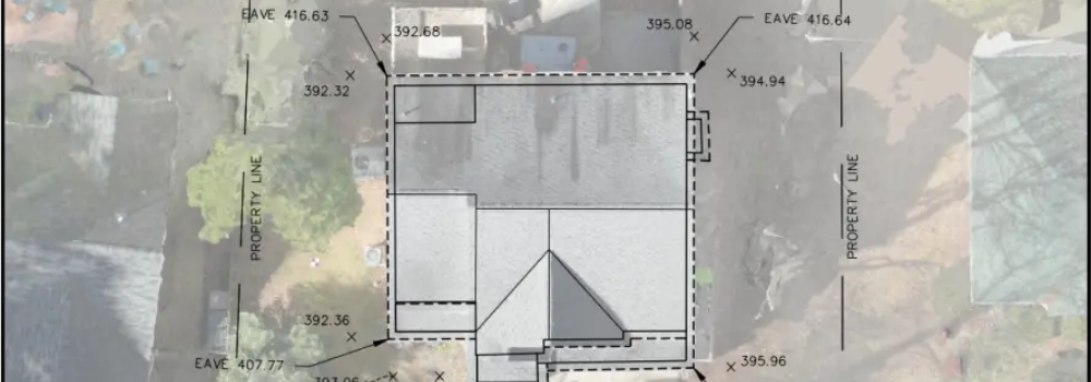
A land survey is a map that pinpoints the precise locations of a piece of property’s borders. The size and location of any structures or other site improvements on the property will also be outlined in a survey. You can hire local land surveyors for this work.
Different land surveying techniques are available depending on the property’s dimensions, shape, and available legal description.
Why do you need a land survey?
Determining the boundaries of your property may need more than just consulting a legal description. You can find your property borders for your own reference or meet certain standards for purchasing or renovating real estate by hiring Local Land Surveyors. Some justifications for a land survey are:
- Finding the lines of property.
- Fulfilling the conditions of the mortgage.
- Obtain title protection.
- Resolving conflicts over boundary lines.
- Being aware of what you’re purchasing.
- Locating easements.
- Constructing a home or other building.
- Updating a property survey that is out of date.
- Locating the utilities.
A land surveyor will need to conduct new measures in order to give precise boundary lines because old real estate legal descriptions might make reference to landmarks or monuments that are no longer on the property. In order to mark corners, the surveyor may also erect new land survey monuments.
Categories in Land Survey
Your reason for requiring a Land Survey Company will determine the kind of survey you receive. Professional surveyors offer property surveys to meet your specific real estate demands, whether you’re looking to divide land parcels or just need to find your property lines. There are different kinds of survey including;
- ALTA survey
- Boundary survey
- Location survey
- Subdivision survey
- Site-planning survey
- Construction survey
- Topographic survey
ALTA survey
When purchasing a house or investment property, an ALTA (American Land Title Association) survey is completed. It is known as mortgage surveys, typically necessary before a company will provide any title insurance.
Boundary Survey
A boundary survey is used to ensure the proper location of the land, its boundary, and corners. It’s necessary to settle any legal dispute or local easements.
Location Survey
It’s similar to a boundary survey, but it’s also necessary for site improvements. In this survey, the process reflects the location and size of improvements and the distance measurements between them and the property lines.
Subdivision survey
A subdivision survey is used to split a piece of land into many lots for development purposes. Subdivision plats are created using a subdivision survey and uploaded to the recorder’s office’s land records.
Site-planning survey
It’s used to plan the development of site improvements. Its aim is to draw inside of boundary surveys. When you are applying for building permits then a site-planning survey becomes important.
Construction survey
In a construction survey, the local land surveyors marked out the locations of anticipated improvements and structures. The surveyor conducts this to indicate to construction workers the locations of planned improvements and the distances between them.
Topographic survey
The position of both natural and man-made features on a site is determined via topographical surveys. Buildings, fences, utilities, ponds, rivers, trees, and altitudes are a few examples of these features. Engineers and architects frequently use a topographic survey to plan site improvements.
What Is the Cost of a Land Survey?
The type of survey, as well as the size and shape of the property, determines the cost of a land survey. It depends on what kind of services you’re getting. Our experienced surveyors can easily provide the best services putting effort and time.
According to several firms, the average cost of a land survey lies between $350 to $700. Properties with greater acreage or corners will cost more for a land survey.
Due to the additional effort required to find documents and provide more information, ALTA surveys typically cost more. An ALTA survey typically costs between $2,000 and $3,000.
It’s important to keep in mind that these are average across the United States. Depending on the specific market and the public documents that are available, the price of a residential survey can vary significantly. According to some reports, doing surveys in California can cost around $1,000 to $5,000. But it depends on how complicated the whole process is.
How to Access Your Recorded Land Survey
You can usually find a certified copy of a land survey in the official records at the land recorder’s office or at the building department’s office. You might also be able to locate the survey filed with the local tax assessor’s office in certain areas.
Another resource for finding a survey is a title business. Title insurance providers will probably have a copy on file because they usually demand an ALTA survey before issuing title insurance.
Qualification for land surveyor
The process of land surveying is extremely complex and error-prone. Each state has specific requirements for who is permitted to conduct a property survey because of how crucial survey accuracy is.
Local land surveyors licensing requirements vary by state, but generally speaking, state surveyor licensing entails:
- Education is required
- Exam
- Minimum experience
A surveyor must do continuing education in the majority of states in order to keep their licence. Most people will obtain a bachelor’s degree in surveying, mapping, or geomatics in order to obtain the education required to work as a surveyor.
The majority of businesses will demand a certain level of experience from surveyors in addition to licensing requirements before allowing them to perform and certify their own surveys.
Conclusion
A land survey will provide precise information about your property’s location and characteristics. A construction crew won’t know where to begin building without clearly defined property limits, and a bank won’t know what it’s lending on. Verify that your land survey is current and includes any new features or improvements to the property. A land survey needs to be accurate in order to be useful.